Tuesday, March 8, 2011

Saying good-bye to sunny Auckland

Can't believe it!  Today we are leaving New Zealand, after a little over a month of non-stop traveling and sightseeing.  We've logged over 3600 km driving this "small" country, and although we've seen many towns and scenic highlights, there is so much that we didn't see!  New Zealand is one of those places where the same spot could look totally different on a different day, depending on whether it's sunny or rainy or cloudy.  So I guess we'll just have to come back in the winter-time to get a new perspective!  Okay, maybe not for another 15 years or so.

Long Beach, Auckland North Shore
Auckland has been a wonderful host to us again - warm and sunny days, a little breezy.  It's seems really crowded here, even though I don't think this is a huge city.  We won't miss the traffic in NZ, it's been a bit surprising.  We WILL miss the mochas, the flat whites, the bacon (you have to taste it to believe how good it is!), and the beautiful scenery.   We won't miss the endless french fries, deep fried everything, the crazy roads, the road construction, run-down motels, and the rain.

We're both ready to come home, but it's been a great vacation overall.  Thanks for following the blog and can't wait to show whoever's interested the rest of our pictures (only the good ones of course!).

P.S. Can somebody arrange for it to be sunny and warm when we arrive in Calgary?  Thanks. :)

Saturday, March 5, 2011

Quick Update from Northland

Hi everybody, our trip is winding down now.  We just spent about 4 days up in the northern portion of the North Island, hoping to just hang out on the beautiful beaches up here and just relax.  Well, we got to relax, but the sun decided to take a vacation too!  We had one day of part sun, where we did a boat cruise into the Bay of Islands, and we got to see some bottlenose dolphins on the way.   They are very playful and let our boat just sit there while we watched them.  Yesterday (Saturday) it poured rain almost all day, and all of last night.  Today it is totally grey and cloudy again, although no rain....yet.  We're heading to Auckland today to spend the rest of our trip.  Let's hope we find a wee bit of sun again!! 

 Take care everybody, and see you soon,
 Nat and Barry

Mar. 1: Adventure-Town - Queenstown!

As we headed north back to Queenstown, the fog was thick in the valleys.  We hoped it would lift so that we could enjoy the spectacular mountain scenery surrounding Queenstown.  And we were rewarded - as we drove around the east side of Lake Wakapitu, the fog burned off the reveal the mountain ranges that rise upwards from the lakeshores.  Took some pics with the other tourists and arrived in Queenstown.  My heart was set on doing some jetboating, highly recommended by friends who've visited Queenstown, and Barry was going to relax for a few hours in town.  There are 5 different companies that offer jetboating action, ranging from wild canyon rides to longer cruises in the Dart River.  Since we wanted something quick, I went for the most popular canyon boating option - the Shotover Jet.  So....
From the gondola lookout in Queenstown

The Shotover Jet runs about every half hour, as the ride lasts only about 25 minutes.  And once you arrive at their Shotover River office (an 8 km shuttle ride from downtown), they quickly throw you a lifejacket and a rubber water robe (it's basically like the cover you wear at a hair salon to protect your clothers), and line you up at the pier to wait for your boat.  Our boat was only about 3/4 full, so of course I choose an edge seat to get as close as possible to those canyons!  I didn't regret it either, as it is definitely more thrilling when the driver zooms you just under cliff edges and you feel like you have to duck your head to avoid getting clocked!  Makes me wonder why we don't wear helmets, as there's a very small margin for error on these rides.  These drivers supposedly get something like 120 hours of training before they can captain these boats - it helps that they are young guys who aren't afraid of what could happen.  Anyhow, it was definitely a good thrill.  Highlights for me were the close canyon turns and going upriver against the rapids!  We did lots of 360 degree spins on the river but they weren`t that scary after awhile.  Amazingly, these jet boats can speed along on only inches of water - the river was very low and we thought sometimes we were hitting the bottom but apparently those were just the rapids we were jumping over. 
After the boat ride, Barry and I met up again in town and we walked up to the Skyline gondola and decided to combine with some luge rides at the top.  These aren`t the luges you find at Canada Olympic Park (thank god!), they are sit-down sleds with handlebars to steer and control your speed.  The views from the gondola and the lookouts at the top were fantastic - you can see why people are drawn to Queenstown for holidays.  I can imagine this would alot of fun in the winter too.  As for the luge rides - really fun, I wish we`d gone for more than the 2 rides!  I was starting to feel that lure of all the adrenalin activites you can experience in Queenstown - there were paragliders taking off from the gondola and I was starting to consider it.  So much to do, so little time, and we had a flight to catch the next morning back to Auckland.  Sigh....

Thursday, March 3, 2011

Quiet Te Anau and Majestic Fiordland

Sat. Feb. 26 to Mon. Feb. 28, Staying in Te Anau

This time I've included a small map of the area we're visiting, so you have a better idea of where the heck in New Zealand we're talking about!   Te Anau is in the southwest corner of the South Island, one of the colder and wetter parts of NZ.
A "greenstone" from Arrowtown
View from roadside en route to Arrowtown
We arrived in Te Anau in the late afternoon after driving from Wanaka, through Arrowtown and Queenstown on the way south.  The drive was surprisingly easier than we thought it would be, with only a few hairy moments twisting and turning on 180 degree cliffside turns on the way down to Arrowtown.  But what views on the way!  Arrowtown is an old gold miners town, and they've kept the main street looking as historical as they can.  It's a quaint town, but kind of a tourist trap as well with lots of little shops and restaurants to spend your money in.  We waited a a half hour for our coffees at a French cafe, something we're running into more and more in NZ - long waits for ordered food/drinks.  I think they're having a tough time getting enough workers for restaurants. Anyways, after getting our coffees we spent an hour or so on their river walkway, where I thought I'd found some real NZ greenstones.  Unfortunately I don't think the stones qualify as official "pounamu", a sacred green stone for the Maori culture.

After a quick lunch of Thai curry rice bowls in Queenstown (really yummy), we carried on to Te Anau.  Stayed at another Bella Vista motel there and made a last minute booking for the next day to go on a Milford Sound bus tour and cruise - Barry and I were both tired of being drivers and looked forward to turning off our brains and having someone else take us around to the sights!!
Marian Falls

Mirror Lakes
Ray, our tour guide, and Natalie


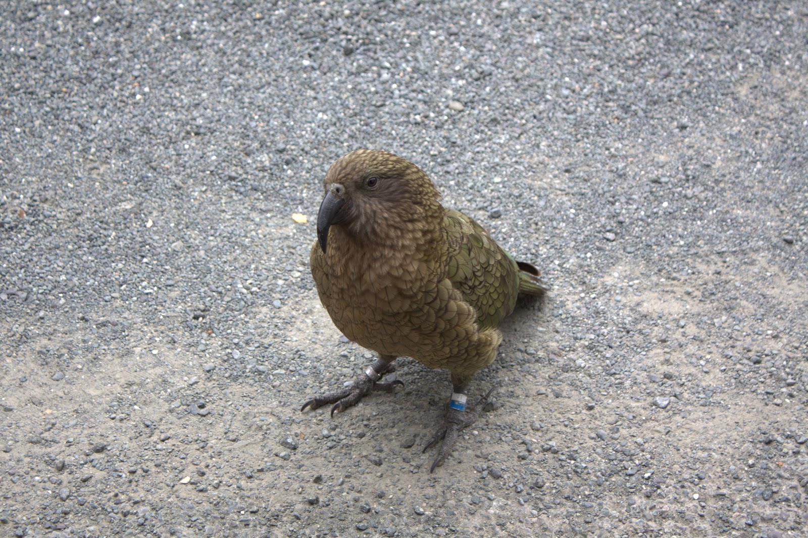
A very curious kea bird before Homer Tunnel
Falls in Milford Sound
Sunday - Milford Sound tour. Weather: Mainly cloudy, cool (finally need to wear pants, not shorts!)  Since all the big tour buses that come from Queenstown were full, we ended up getting booked on a local Te Anau tour bus, Fiordland Tours, which hooks up with Mitre Peak Cruises in Milford Sound.  We totally lucked out with this one, as Ray, our tour guide, was so knowledgeable and really cared about having us see all the photo stops on the way.  There were only 7 of us on his small bus, so no waiting for big groups to get one and off at each stop.  The group included 4 fun ladies from Queensland, Australia, who were old school buddies, and one Japanese girl who was a refugee tourist from Christchurch.  We must have made around 9 stops on the way to Milford, including Mirror Lakes, The Chasm falls, and  a coffee stop in Holyford Valley. 
Overall it was a fun tour, and we enjoyed the cruise of Milford Sound.  Again we lucked out as there were maybe 15 of us on the boat cruise, so everyone stayed up top to get the panoramic views of the fiords.  Highlights were definitely the falls, but unfortunately the day was pretty gloomy, so the fiords looked a bit desolate to us, and often in high cloud.

Kepler Track near Te Anau
Monday, Feb 28. Weather: Partly sunny in morning, cloudy afternoon.  Barry and I had a quieter day today, with not much planned in Te Anau. The forecast for the Fiordland National Park area was supposed to be socked in and rainy, so there was no point in doing the Key Summit hike, part of the multiday Routeburn Track.  The point of that hike is to get fantastic views of the area, and there would be no views in the bad weather.  So we did a short portion of the Kepler Track, in the beech forest along Te Anau.  Very pretty forest, but we noticed there were a lot of trees marked with signs that indicated traps nearby.  We started to spot the traps, which were likely for stoat or possums, regarded as major pests in New Zealand.  That's why you'll sometimes see possum fur combined with merino wool in clothing - make some use of the poor pests, I guess.  It's hard getting used to the unique problems they have here with introduced animal species that have wreaked havoc on ecosystems and native birds and animals.  Many of NZ's native birds have no natural predators, so they haven't evolved with any way to protect themselves from excellent predators like the stout (which was brought in to deal with the rabbit overpopulation originally).  And the possum is eating away at native trees.  So in a nutshell, now the Department of Conservation is trying to kill off the stoat and possum populations.

Wednesday, March 2, 2011

Visiting Mountain Lakes: Tekapo, Pukaki & Wanaka

Feb 23 - Feb 25:

It's been another busy week for us, with loads of driving and lots of pretty lake scenery! (And very little internet access). Here's a quick summary:
Lake Tekapo

Church of the Good Shepherd, Lake Tekapo
Barry mistakes a horse tie-up for a ballet bar at Lake Tekapo-oops!
 On Wednesday, we visited Lake Tekapo en route to our 2 night stay in the small town of Twizel. Lake Tekapo is a beautiful icy blue colored lake, surrounded by mountain scenery and tussocky hillsides.
 Looking over the lakefront is the tiny Church of the Good Shepherd, built in 1935. We hiked to the summit of Mt. John, and returned via the lakeside, a hike of about 3 hours length.  We soaked up the views even though it was drizzling rain and cloudy, and slurped up delicious mochaccinos from the coffee shop at the top.  There is an astronomy observatory at the summit run by the Earth and Sky company http://www.newzealandsky.com/earthandsky/index.html
- something you can visit at night to look at the stars.  Interestingly, this was one of the few walks we've done in NZ that wasn't crowded on the trails - a nice change.
 
An overcast day looking into Hooker Valley
On Thursday, we drove past Lake Pukaki on our way to Aoraki/Mount Cook National Park.  Our plan was to hike the very popular Hooker Valley Trail, which takes you along the valley floor and gives you good views of Mt. Cook peak.  The day was mainly overcast and windy, and we started our hike mid morning.  The trail was very busy, it seemed there were hundreds of people walking this trail that day.  Again we felt like we were one of the few Canadians here - most of the visitors were either British, German, or Asian, and age-wise, we are not the common demographic. Most visitors we've come across are either 15-20 years older or younger than us.
A spiky Golden Spaniard plant

Tasman Glacier & Tasman Lake - see those icebergs!
Amazing view from Tasman Glacier lookout
Overall the trail was more of a walk than a hike - very few gains in elevation, and it's a one way track so you retrace your steps back.  I think this walk is overrated in terms of views and variety of scenery.  Maybe it was because of the high clouds concealing the peaks at times, or the crowds, but the highlight was probably seeing the glaciers clinging to the sides of Mount Sefton and Mount Cook.

The Visitor Centre in the village is worth a look - great history of the mountaineering in the area, including artefacts from times past including the wooden slats they used as skis and the changes in camera technology over the years.
Another stop worth visiting are the Blue Lakes from the Tasman Valley Road (8 km of gravel road off the Mount Cook Road).  A 20 minute hike up gives you fantastic views of the Tasman River Valley and the Tasman Glacier, the largest glacier in New Zealand.  The Tasman Lake below it is full of icebergs, and a huge chunk of the glacier actually broke off during the earthquake in Christchurch - causing some large waves and scaring the heck out of the boat passengers visiting the glacier at the time!   (No one was hurt, by the way.)

That night as we ate our pizza at an outdoor cafe in Twizel, a family of Canucks happened to site down beside us.  The friendly dad told us they were from Humboldt, Saskatchewan, and had traveled to NZ for a wedding.  They were in the CBD of Christchurch when the quake hit, and were lucky the parking garage their rental car was in didn't collapse.  They basically just jumped in their car and fled out of the city like everyone else and ended up in this area.
 
Barry and Nat at the Wanaka Lake Lookout
Friday we left Twizel and drove another hour to Lake Wanaka.  Who knew this was such a happenin' town?  We think maybe they're competing with Queenstown to be the tourist attraction of the area.  Here's where we started to see people with money to burn - big holiday homes, fancier restaurants, nice cars.  The lake front area is full of restaurants and people out for a stroll.   After enjoying a sloppy beef burger and yes, fries again, later in the afternoon we set out for a quick hike to the Diamond Lake loop.  After a bit of a grunt up, we were lucky to get some late day sun and some fantastic views of the surrounding mountains, towards Mount Aspiring National Park to the northwest, and south to Lake Wanaka.  We heard and saw lots of birds in the forest canopy.   Wish we'd had more time in Wanaka, there were other hikes to nearby summits that would provide excellent views of the area.
Oh well, next day we were off to Te Anau via Arrowtown.

Thursday, February 24, 2011

More Furry Seals and Dolphins too!

Mon., Feb 21 & Tues. Feb 22nd Cont'd:
Those brown blobs are all seals!
Fur seal babies playing in surf pools
After we went sea kayaking and were fully recovered, later in the afternoon we drove back north along the highway to a spot where you can see even more seals and a nice waterfall.  The area is called Ohau Point, and from the highway lookout you can see hundreds of fur seals below on the rocks and in the surf.  This is an active breeding colony, so we could see males, females and baby seals interacting in a pretty crowded area.  Took some video footage here, but don't have enough upload time to get it on the blog.  Sorry!
 

Ohau Waterfall
We stopped a little further and visited the Ohau Waterfall, accessible via a short 10 minute walk in from the highway pull-off area. Again, you walk through beautiful lush forest which brings you to a really pretty waterfall and pool below.  It's almost mystical in here, and for once, there weren't crowds of people sharing the same trail with us!  The information on the signs informed us that the Ohau Stream up to the waterfall is used by baby fur seals for shelter in the winter time while their mothers are feeding at sea.

The next day, Tuesday, we departed Kaikoura for Christchurch.  About half an hour south of Kaikoura, I was scanning the ocean for signs of whales, and suddenly saw what looked like large fish leaping out of the ocean.  Luckily there was a turnoff shortly ahead and we pulled off with some other cars.  Sure enough, they weren't fish - they appeared to be Hector's dolphins, a smaller dolphin found in this part of the world.  There were several large pods visible offshore, and with the help of the binoculars, we could see groups of them jumping and flipping over the water.  We watched them for 15 or 20 minutes or so, then moved on.  In a way, these dolphins delayed us from reaching downtown Christchurch for the earthquake, so thank you to the dolphins for being a distraction!!

Wednesday, February 23, 2011

Kayaking in Kaikoura

NZ fur seal relaxing on the rocks in Kaikoura
Monday, Feb. 21: If you're into marine wildlife viewing, Kaikoura is the place to be.  And to boot, it has dramatic surf and coastlines and mountain landscapes surrounding it.  Some of your choices for adventure in Kaikoura include: whale watching, dolphin watching/swimming; albatross watching; seal swimming and sea kayaking; and hiking.

This was a second location I could have gone swimming with dolphins, but alas, it was not meant to be. On Sunday afternoon when we enquired with Dolphin Encounters, they were fully booked for Monday except for 5:30am, and those that know me, know that would be impossible.  So, we did some more research, put ourselves on a waitlist for whale watching Monday morning, and by Monday morning, we decided whale watching was overpriced for seeing a couple whales ($145 NZD). There was also a good chance the boat could be rocky, not so great for Barry and potential seasickness. So...we went with sea kayaking to see some seals up close and personal with Kaikoura Kayaks.

Tuesday, February 22, 2011

Witnessed Mother Nature's Power

Thought we'd better update the blog tonight and let everybody know we are safe and sound in Timaru, around 2 hours south of Christchurch.  It's been a very long and stressful day after leaving Kaikoura.

You may now have heard about the Christchurch earthquake that hit today at around 1pm.  Barry and I were on our way into downtown Christchurch and missed being there for the big quake by about 20 minutes.  We thought our car had a flat tire when we were just outside Christchurch, but that was actually either the first quake or the aftershock we were feeling.  Barry could barely control the car as we were swayed left to right going 100km an hour on the highway!  It wasn't til we had pulled over and got out of the car and saw others doing the same that we realized it was a tremor.  Silly us, we thought tremors were normal around here.  Unfortunately, this was a shallow earthquake that caused much more devastation than the 7.2 magnitude quake they had in September.  So far, 65 people are confirmed dead and more are expected.  Others remain trapped in downtown buildings.  We are truly blessed to be safe tonight.  There are so many distressed people in Christchurch right now, everyone is talking about it and many have been affected by it.  Keep them in your thoughts.


Take care all, and be thankful if you don't live in an earthquake zone!
Nat and Barry

Monday, February 21, 2011

Abel Tasman Park

Saturday, Feb. 19:
 
Lots of interesting rock formations
Had a horrible night's sleep at Bella Vista last night after partyers a couple units over were talking loudly and drinking until 2am.  Which meant we decided to checkout and find somewhere else to stay.  Took the Discovery Day tour from Abel Tasman Sea Shuttle, for $72 each.  Ended up booking it at the Eden's Edge Backpackers lodge in Motueka on the way to Kaiteritiri beach.  Unfortunately Eden's Edge was booked for accommodation for that night, but she was more than willing to book the shuttle for us, as she gets 10% - very nice, talkative lady actually.  Turns out you can just book the various boat tours at the beach, but it was pretty busy when we got there.
Golden sand beaches, but cold water!
We enjoyed the cruise for the first hour or so, as the various bays along the coast are very pretty, with golden beaches, greeny blue water and rugged rainforest down to the shoreline.  The boat was pretty full.  The Sea Shuttle basically stopped in six bays to drop people off until we reached the top bay, Totaranui Bay. Then on the way back, we stopped again in a couple bays before dropping us off in Bark Bay at about 1:30pm.  There is a 6 km coast track hike south towards Torrent Bay, where we were scheduled for shuttle pick up at 4:45pm.  You could add on another 30 minute walk to the adjacent Anchorage Bay, if it was low tide, or another 90 minutes if high tide.  

Track between Bark Bay & Torrent Bay
The hike was enjoyable, again through lush forest including black beech trees (although it appeared to be quite dry while we were there) with peeks here and there at the luscious blue ocean.  Everything is so green here, not much color variation or flowers.  Also got to cross the Falls River swingbridge, not for the height-sensitive types (Mom you'd hate this!).  We arrived at Torrent Bay just after 3 pm, and decided we'd hitch a ride on the earlier boat back to Kaiteriteri at 3:45pm.  Alot of people got wet boarding the boat as some swells came into the bay just as we were wading in th water onto the gangway.  Headed back to Nelson to find accommodation, and stayed at the much quieter Amber Court Motor Lodge in Tahunanui near the Bella Vista.  The owner was a wise guy though, teasing us about our wimpiness on the roads here, telling me to go the local hardware store, buy some concrete to toughen up!!  The cheekiness!!

Tahunanui Beach at dusk, Nelson
Just wanted to add that the main beach in Nelson, Tahunanui Beach, is absolutely beautiful, and under-rated compared to the pebbly but golden Kaiteritiri beach by Abel Tasman park. It was right near our hotel in Tahunanui so we visited it in the evenings both nights.  The beach is almost flat, so at low tide, the sand seems to go on for miles, and the sand is soooo soft, with no rocks and a few shells.  This is a great swimming beach - unfortunately we ran out of time for that.

B-bye Wellington, Hello South Island!

Friday, Feb. 18th
Forgot to mention we visited the Te Papa museum in Wellington yesterday.  Good museum, but absolutely huge!  We didn't see all of it, but gave it a good 3 hours. Highlights were an "earthquake house" that simulated what an earthquake would feel like indoors - very freaky; and dioramas of animals that have lived or still live on New Zealand including the flightless kiwi bird, which is only found in a few spots in NZ now. Today we left Wellington for Picton via the infamous Cook Strait ferry crossing. Alot of folks who have visited New Zealand warned us that this crossing can be really fun - if fun for you means a really rough boat ride that lasts over 3 hours!!  Thankfully, Mother Nature smiled down on us on Friday and we had sunny skies and calm breezes, so no seasickness problems!  As we waited in the passenger vehicle line up to load the 10:30am ferry, we chatted up a local couple who were heading to Abel Tasman park for the weekend.  Gave us some ideas on other places to visit and hike on the South Island, including Arrowtown near Queenstown. We've come to realize that alot of people down here have never heard of Calgary before, so it's kind of fun filling them in - this middle aged couple had never visited Canada before. 

Drive from Picton (ferry arrival town) to our destination, Nelson, was, ah, interesting.  Okay, it was crazy busy and a white knuckler for a good half of it.  Glad to arrive safe and sound in Nelson. 

Wellington, Hutt City and the search for Rivendell

Wed & Thurs, February 16-17th:
Wednesday was pretty much a travel day as we made our way south from Tongariro down to Wellington, on the southern tip of the North Island.  We chose a route that kept us on the main highways as much as possible to speed up the driving.  However, we ran into lots of traffic and more road construction.  And the first third of the drive was one of the worst roads I've ever driven - more on that on a future post about our ratings of the roads here! Interesting note: We've noticed the road crews are often made up of older men, not just the young punks we use in Canada - wonder why?  We left Tongariro before 9 am and didn't arrive in Wellington until around 3pm.  Long driving day that's for sure.  Even better was that there was no accommodation left in Wellington that night, so we had to stay in Lower Hutt (or Hutt City), a bedroom community outside of Wellington, AND, we booked our hotel through an I-Site visitor centre (there's one in every town/city), and discovered they charge a booking fee to the hotel (and then to the customer) of 10-20%.  So we payed $130NZD for a dumpy hotel in Hutt City, that is $110 if you book directly. Oh well, at least we know that now.  The lady there did call around to a lot of hotels to find us something so I guess she earned it, and she booked our next night's motel in Wellington. Walked along the river through Lower Hutt in the evening, and lots of people were out jogging (everybody runs here) or walking their dogs off leash.

Thursday was a better day.  This was our search for Lord of the Rings (LOTR) sites and in the afternoon, a visit to the Te Papa museum in Wellington.  Wellington and surrounding areas were used extensively in the filming of LOTR movies, and they're at it again with The Hobbit now starting up. Everyone's just waiting for the director, Peter Jackson, to get over his ulcer.

Here's our independent tour of some LOTR sites:
Helm's Deep - Gravel Quarry outside Lower Hutt
- Helm's Deep (now a dry gravel quarry with limited access). Doesn't look like much now.
River Anduin location
- The Great River Anduin (part of a Hutt City park that runs along the Hutt River). The river is very low right now, so it's a little hard to imagine this scene.

- Isengaard (another Hutt City park).  This one stumped us - seriously looks like a lovely open space for a picnic, and there's a big playground with a zip line. Ummm, think they used a few computer graphics to make this look like a fortress for Saromen.

Rivendell in Kaitohe Park
- Rivendell - Forest of the Elves. Definitely the best LOTR site of the bunch.  This forest actually looked like it could be used in the movies, and is signmarked with info on the filming location.  Only a 10 minute walk from the carpark at Kaitoke Regional Park, you're in the middle of a forest that was used for Rivendell.  Even better, there was a film crew set up in a nearby parking lot, and we saw some actors dressed as medieval warriors.  We also saw a production crew setting up tents and props along the river. When we asked a crew member what film they were working on, he joked and said it was a little movie called The Hobbit, then he said it was actually a small scale movie about zombies or something.  Hmmmm, I wonder.

Saturday, February 19, 2011

The Tongariro Crossing (aka Tongue-Out Crossing/Up the Ant Hill we go)

Tuesday, Feb. 15th.

Mt. Ngauruhoe (last eruption 1975)
Crossing the South Crater
Crossing distance: 19.4km
Additional roundtrip hike to the Mt Tongariro summit: 3km
Difficulty: Stiff climb up, and up, and up, and then non stop down, down, down. Only a couple km of flats.
Start time: 8:05am   Finish time:3:45pm  Duration: 7 h 40 min
Can't say enough about how pleasant the owners are at Adventure Lodge, Ron and Lorraine.  Gave us great advice about the hikes in the Park and never tried to push any extras on us.  Lorraine drove 10 of us to the start of the Crossing - about a 25 min drive from the Lodge.  Met some really nice people on the bus - 1 young couple from England, and 3 couples from the U.S., two travelling together from Florida and the other couple from Boston (Peter and Dee).  Peter and Dee had visited Lake Louise before and loved it but never spent time in Calgary.  Besides these Americans we met, there are visitors in the Park from all over the world as we heard people speaking German, French, Italian, Scandinavian languages, lots of British (is that a different language?) and others.
There's not much in the way of parking at the Mangatepopo trail start, almost like they are discouraging people from taking their own cars. Costs only $30pp for a return shuttle - well worth it as the buses pick you up from the end of the trail at Ketetahi Car Park.  However, both Barry and I thought that the best part of this hike was the first half (about the 9K mark), and you could actually turn back and hike back to the start.  The second half was not as dramatic or scenic, and is quite a long slog for less payoff (10.5 km).  I guess we're spoiled getting to hike in the mountains by Calgary - the scenery at home is hard to beat.
The first 2 or 3 kilometres to the Mangatepopo (sp?) hut is fairly flat, a slight uphill grade. Run into lineups at the 2 porto-potties at this stop however, since we were following a few groups of girls.  Seems like they should have more facilities considering how busy this trail is, and this was mid-week!  After this hut, the trail began to climb. Sometimes you had to climb over rocks, which would be a challenge for less mobile types.  They've built lots of stairs, and when you look up or back, you see a row of ants, which are the hundreds of other hikers sharing the trail with you.   Thankfully it was not a hot day, but you still are drenched in sweat as you climb the track towards the Southern Crater.
Panoramic view within the South Crater
When you walk across the flat floor of the Southern Crater, you feel like you're on the moon.  No vegetation, just a mud floor, and lava rock surrounding you on all sides. And you look up at Mt Ngauruhoe, and you can understand why they used in Lord of the Rings as Mt Doom.  It's the perfect volcanic cone shape, and enticed a few hikers up it's summit trail.  This trail is difficult as you have to climb across loose scree on a steep slope - no thanks, looks good from the bottom!!
As you climb out of the Southern Crater, you eventually get to a ridge where lots of us stopped for a bit of lunch.  You also get a glimpse over the edge of the Red Crater below.  At this point, Barry and I debated whether we wanted to do the Tongariro Summit, another 3 km. We'd already hiked about 9 k, and our legs were tired.  But, being this close to the summit, why not?  It looked pretty cloudy up there, which would wreck the views, but what the heck.  You should not tackle this unless you're sure you have enough energy left to finish the Crossing.  It is more climbing, not just a flat 3 k.  It adds another 1.5 to 2 hours to the hike.  Unfortunately, at the top, the mist came in and we couldn't see to the north, but could see Mt Doom to the south.  Basically we tried to jog it back to gain some time as our bus was coming at 4pm.
Red Crater
Climbing yet another ridge we got a fantastic view of the Red Crater, now vivid in the mid afternoon.  Then we got to have some fun, almost skiing down the loose sandy scree towards the  Emerald Lakes below.  It helped that we've dealt with scree before, and you just dig your heels in and go with the flow.  We passed alot of hikers here who were fighting the scree and were getting really frightened. 

After this, there weren't as many highlights for us.  We stopped to eat our lunch at the larger Blue Lake, which became swallowed up in the mist right in front of us.  The rest of the hike was just trying to get down as fast as possible, and the views were obscured on this side of the pass because of the low cloud.  The last 3 km or so is in a lovely forest like Taranaki Falls, but I was too tired to enjoy it.  At last, we reached the car park and thought our legs would never recover.  Amazingly, we weren't that sore the next couple of days - who has time to be sore in New Zealand!!

Thursday, February 17, 2011

Gollum and Mordor

Monday, February 14th.  Drove from Taupo to the Tongariro National Park.  We were pretty excited as we were heading to the infamous Mount Doom from Lord of the Rings films.

 
After checking into our Adventure Lodge motel, we chatted with the friendly motel owner and he gave us some tips for some short hikes for the rest of the afternoon.  And, for you LOTR fans, we finally met one of the stars from the movies!  Here's his picture as proof. (The owner said it was portrait of his mother in law, but I think he was just kidding!!)

Meads Wall
In the afternoon, we visited Meads Wall in Whakapapa ski Village.  Don't remember this from the LOTR movies, but the rock wall involved an important scene with Gollum, apparently.

Will add more to this post later...
Sorry for the delay folks, we've been on the road alot lately and little time to blog or get internet access.

Starting after 4 pm, we hiked the Taranaki Falls trail, a 6K loop that starts near the Chateau Tongariro in Whakapapa Village.  Overall, a pretty easy hike that took us about 1.5 hours. The start of the trail crossed a scrubby, bushy open area that reminded me of scenery in the Okanagan of BC.  Then we suddenly entered this oasis of lush ferny forest that followed the creek.  Most of the trail to the Falls remained in the forest, which gave us some breaks from the hot late afternoon sun.  When we arrived at the Falls, we realized this was a happening place! 
A huge school group of high school age boys had already settled in to the pool at the bottom of the falls, some going for dips.  Needless to say, it was too crowded for us to go down there, but the view of the falls was nice.  To prove that there are stupid people everywhere, a young couple hung out on the rocks just above the falls - it would be easy to slip and fall there - ah, Darwin's law at work. Ironically we saw this same couple among the hundreds on the Tongariro Crossing the next day, AND we saw them a few days later on the ferry from Wellington to Picton!

Rotorua & Lake Taupo: Bubbly things and intro to Maori culture

Sunday, February 13th:
It's been a few days since I've blogged so I'm trying to remember what we've done the last few days - it's been action-packed!  On Sunday we explored the Rotorua/Lake Taupo geothermal region.  We were kinda choosy about what we did as we've already been to Yellowstone and the geysers and pools there are pretty amazing.

The unidentified white birds!
In the morning we toured an art market held in the Government Gardens area in Rotorua, watched some lawn bowlers, and strolled a bit around Lake Rotorua.  They have very friendly black swans there, and some large white birds that look like fat geese to us, have no idea what they actually are (sorry to the birders out there, maybe you can help identify them?)

Then we headed to a living Maori village called (and make sure you say this out loud and replace "Wh" with a "f" sound to say it properly!) - "Whakarewarewa". Check out their website here:
http://www.whakarewarewa.com.   Our Maori guide, nicknamed Annie, was excellent, and told us about the residents' everyday life.  The steam cooking methods are really interesting - they just place their roasts and vegetables, even puddings, inside their geothermal cook ovens outside their homes, and the ovens work like slow cookers, almost never overcooking the food!  Annie said that the villagers share the ovens and often the meals as well.  They also bathe in some of the warm pools there, which are steaming all around their homes.  Some of their relatives lived through the Mt Tarawera eruption in the late 1880's, which destroyed several villages closer to the volcano.  We also checked out their cultural performance in the afternoon, and saw our first "Haka" dance, the warrior dance, where the guys stick out their tongues and try to look threatening.  Our performers were more funny than scary though :)

Back on the road heading south to Lake Taupo, we stopped at another geothermal hotspot, the Waimangu Volcano Valley.  From here, we got a spot on view of Mt Tarawera, which erupted in 1886 and created the Waimangu Volcanic Valley - the youngest geothermal spot in the world. The largest geyser in the world, the Waimangu Geyser also erupted in 1900 and killed a few visitors in 1904.  Barry and I both felt a little uneasy as we walked through this steaming, bubbling valley, as we had witnessed a rare major eruption of the Steamboat geyser in Yellowstone in about 2005. It hadn't erupted for several years and freaked us all out! 
 Anyway, nothing like that happened on this day, thankfully!  On to Lake Taupo, a huge caldera lake created after a giant volcanic eruption thousands of years ago.  Man, you just can't escape volcanos in New Zealand!

Had a great supper in Taupo, looking out over the lake. It is as big as an inland sea, and we watched a beautiful sunset there.  Our suppers were delicious - had steak grilled on a super heated lava stone - yum!

Sunday, February 13, 2011

Hiking, swimming, giant kiwis and rotten eggs!

Panoramic view from top of Papamoa Hills hike
Saturday, Feb. 12th.
After Nat’s dolphin swimming was cancelled, we woke up to a beautiful blue sky day.  We scanned the skies looking for signs of the “bad weather” that had caused the cancellation, but it wasn’t overly windy and the clouds were far away on the horizon.  Maybe weather forecasters are as accurate here as they are in Calgary, ha ha ha. 
Got going a bit late after checking out before 10am. Filled up the car with gas, cost over $60NZD, at $1.99 per litre.  We had driven 400km on the first tank. Grabbed a mocha and the most delicious savoury muffin at The Hub, a coffee shop right next to the Shell. Man these Kiwis know how to do breakfast food!!

Path to summit of Papamoa Hill
We decided to leave Tauranga and head southeast down the coast towards Papamoa. Barry found a good short hike in the Papamoa Hills, which would give us panoramic views in the area. On the way, we took a wrong turn (that’s been happening alot in the Tauranga area, which lacks signs for key freeway turnoffs!!) and decided to check out Papamoa Beach beforehand. Glad we did, as it looked like a nice swimming beach, with lifeguards on duty, changerooms and lots of places to sit on the soft sand.  We decided we’d come back here after the hike to go for a dip and relax.

Friday, February 11, 2011

South to the Bay of Plenty

Today we drove south and east from Auckland to the Bay of Plenty region, the fruitbowl of New Zealand.  So far we've only purchased some NZ apples, but no kiwifruit yet!  We'll sample some soon, we promise!  Our destination was the city of Tauranga, where I was planning to go on a dolphin swimming, whale watching excursion into the bay on Saturday morning.  Sadly, because of expected rain and wind tomorrow, found out this evening that it is cancelled.  I'm very disappointed but hoping that we'll be able to catch up with those dolphins in some other part of NZ later on in the trip.  There are several places you can do it, on both the North and South Island.


View from summit of Mt Maunganui
The drive to Tauranga showed us the pretty rolling farmland and countryside of NZ.  It's so green here it's a nice change from the browns and whites of the scenery in Calgary.  Also, we stopped at another beautiful beach in Waihia, a little northwest of Tauranga.  Hardly anyone at this beach, but it had the same soft blackish sand we saw in Piha yesterday.  If it was a little warmer today, would have loved to go swimming here.  The beaches we've seen so far in NZ rival those of any we've seen on our vacations, including Hawaii and Mexico.
Barry on Mt Maunganui
In late afternoon, we hiked up to the summit of Mt Maunganui ("large mountain"), right near Tauranga.  This was our Stairmaster, Part Deux (if you read yesterday's post).  Known by Maori as Mauao, it is a spiritual place for them and very sacred.  No development is allowed on the mountain. 

Thursday, February 10, 2011

Thursday, Feb. 10 - The Road to Piha Beach

Yesterday was an interesting day of driving to say the least!  Poor Barry drove most of the winding road to Piha from Auckland with its lovely blind corners and very narrow lanes with no shoulder.

Leaving behind the morning rush hour traffic of Auckland, we headed west towards the West Coast to check out the black sand beaches of Piha and Karekare (site of several film locations including The Piano).  We took a crazy video on the road that winds down the final stretch to Piha, and if you ever watch it, take some Gravol beforehand if you tend to get motionsick!  The beaches were both beautiful, the sand is so fine it's like baby powder.  The surf is a little rough, so I lost my nerve to go bodysurfing out there. And there was a water quality warning for Karekare beach against swimming. Got a nice burn on my feet and my chest though, where I obviously forgot to put enough sunscreen!  Sun is extremely strong here, no doubt about it.

After visiting the beaches, we took the Scenic Drive back towards Auckland via the Waitakere Ranges and the winery town of Swanson.  The area was thick and lush with vegetation, similar to a rainforest, and quite mountainous.  We stopped for a hike called Fairy Falls.  I'll call this hike "Stairmaster, Part One", as you head down, down, down into the forest on a steep path and stairs, knowing that you are going to have to trudge back up at some point!  There were Kiwis actually running back up, just to humble us even more.  The destination was thankfully worth it, with spectacular falls and pools just inviting you to jump in!  We dunked our feet into one pool, felt great.  The way back was indeed a tad difficult, but at least it was a fairly short hike, in total around 1 hr, 15 minutes.

In the evening, we drove over to the posh district of Mission Bay, where million dollar apartments are the norm.  The main beach road has a seawall boardwalk and row of funky restaurants and cafes, full of people walking, people watching, and having picnics in the park area.  We tried our first "fush and chups" meal at a small takeaway place, and had takahiri fish - a nice mild white fish. Yummmm.